About Hurworth on
Tees.
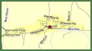
For a larger map of Hurworth click the map or here for an
even larger map
A picturesque village located 3 miles south east
of Darlington and bordering the river Tees. Hurworth borders a single main road, which confusingly enough changes
its name what seems like every 100 metres or so from Hurworth Road, Croft Road, Neasham Road along its entire length
from the junction with the A167 at one end to the village of Neasham at the other. Well done, Darlington Planners...
Not.
Gazza's coach driving skills and the recently opened Middlesbrough Football Club training ground have put Hurworth
on the National News map.
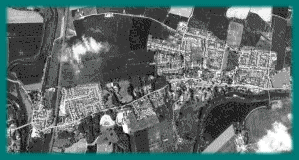
| This image was taken from a Soviet Spy Satellite
orbiting the earth at an altitude of 226.5 kilometers on 22 May 1988 2:17 PM GMT. It is part of a collection of
SPIN-2 Imagery held and copyrighted by Aerial Images, Inc. and SOVINFORMSPUTNIK. Follow the link to visit the Terraserver Page and see other satellite images of the world including Man made and other Natural Wonders from space. Oops, as of October 2nd, 1999, the images covering the North East of England are not available. To find Hurworth, use the search term Darlington, United Kingdom and move south. Click on any part of the photograph to centre it in the page and use the zoom feature for a closer view. The star on the street map marks the position of the Spar shop in the centre of Hurworth at the junction of Croft Road with Roundhill Road and Blind Lane. |
North
|
|
| This photograph is centered on the junction of Elmfield Road with Croft Road. In the south west corner, Croft bridge crosses the River Tees. On higher resolution images available from Terraserver, the arches on the bridge are clearly visible and can be counted. The east coast railway line runs from the south west corner to the north west corner where it lies parallel to the River Skerne. | The A167 exits the image to the west crossing the River Skerne as it does. Hurworth Road runs from the south west corner over the railway line and exits the image to the east. On the north side of Hurworth road lie, the Grange estate, Hurworth Grange Community centre and agricultural land. Rockcliffe court surgery and Hurworth Comprehensive School are on the south side of the road . The River Tees borders Hurworth at the eastern end, with the foot bridge across the river clearly visible above the edge of the cloud. |
![]()
June 10th 1999.