| The Five Villages. Hurworth, together with Croft, Neasham, Middleton and Dinsdale, border along the River Tees about three miles to the south east of Darlington in County Durham. They are all situated on ancient crossing points for the River Tees, the ford at Neasham can still be seen and used, during low water. River Tees Border The River Tees rises in the North Pennines at Tees Head near to Cross Fell and has for centuries marked the border between regions, tribes, countries and nations. Today the Tees marks the County Boundary between Durham and North Yorkshire. Four of the five villages which lie on the north side of the river are historically part of County Durham, Land of the Prince Bishops. However the fifth, Croft lies on the south side and is part of North Yorkshire. Coincidentally as in previous years, the River Tees marks a political divide. The Prime Minister Tony Blair is the local Member of Parliament (MP) for the Durham villages in the Sedgefield Constituency and William Hague, Leader of the Conservative Party is the MP for Croft in the Richmondshire Constituency. |
|
| Croft Bridge. From medieval times, Croft has been linked by the sturdy but graceful bridge which carries the Great North Road or A167 onward to Darlington and sends a road directly to Hurworth on Tees, Neasham and Middleton. The bridge was a turnpike from Yorkshire into Durham from 1745 - 1879. 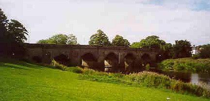 Until 1826, each new Prince Bishop of Durham was presented with the sword known as the Falchion on
this bridge. Bishop Jenkins has recently revived the ceremony, but now the Sword is presented by the Mayor of Darlington.
The ceremony previously took place at Sockburn or Neasham Ford. Until 1826, each new Prince Bishop of Durham was presented with the sword known as the Falchion on
this bridge. Bishop Jenkins has recently revived the ceremony, but now the Sword is presented by the Mayor of Darlington.
The ceremony previously took place at Sockburn or Neasham Ford.Legend has it that John Conyers slew a dragon, the Sockburn Worm with this sword. After the battle, the grave was marked with a great, grey stone- still there today. The story so impressed Officers of William I seeking to raise support for the Norman cause, that Roger Conyers (head of the family) was made Constable of Durham Castle. The legend possibly relates to plundering of the North by long forgotten Viking invaders or refers to the period in English history known as the Harrying of the North by William the Conqueror. In revenge for massacres of Normans at Durham and York, William laid waste to the North, burning every building and killing every man, woman or child, together with their livestock, that his army encountered as they devastated the countryside. The long grey worm spreading fire and devastation would be a column of soldiers on the march. A bridge has stood here for centuries with successive modification and reinforcement over the years to withstand the ferocious Tees floods. Records indicate that a bridge was repaired in 1356. Local anglers use the remains of a red sandstone structure dating from the 15th Century as stepping stones to reach fish in deeper water. The old pillars are still visible downstream from the current bridge when the water is clear. To the south of the road bridge lies the Tees Bridge which carries the main London to Edinburgh railway line over the River Tees. Both the present Croft bridge and a similar bridge linking Egglescliffe in Durham with the town of Yarm in Yorkshire, were built by Walter Skirlaw, Bishop of Durham, around 1400. A Blue Stone of Frosterley marble recording its restoration in 1673 is found on the third arch from the Durham side and marks the County Boundary line. Unfortunately, it has not weathered well and only a few letters of the original inscription are legible, although the fossils inside the marble are extremely well defined. The bridge was repaired again after the catastrophic flood of 1771 and widened upstream in 1795 using hard brown sandstone. 95 yards of the bridge are in North Yorkshire, and 53 yards in Durham. The bridge has seven arches with the northern most arch being smaller than the others, all are clearly visible on photographs taken by Soviet spy satellites. |
|
| The Tees Looking upstream from the bridge, the river Skerne which flows through Darlington joins the Tees. When the water level is low, parts of the stony river bed are exposed and the river travels at a gentle pace, seemingly in peace. Anglers and visitors enjoying the view sit on the grassy slopes or on the benches, whilst children play nearby. Upon closer inspection, both the height of the river bank and the distinct grooves or markings on the Croft side give clues to another aspect of the River Tees. 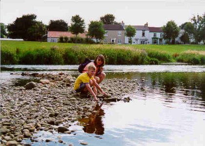 The River Tees rises in the Pennines and travels down to the sea at Middlesbrough across
the agricultural valley, where Darlington originated as a large market town. Its name is derived from its Celtic
name 'Teis', meaning 'boiling, surging water' describing its appearance after heavy rain or snow fall in the hills
when the river thunders down as a wall of water. The River Tees rises in the Pennines and travels down to the sea at Middlesbrough across
the agricultural valley, where Darlington originated as a large market town. Its name is derived from its Celtic
name 'Teis', meaning 'boiling, surging water' describing its appearance after heavy rain or snow fall in the hills
when the river thunders down as a wall of water.Over the centuries, it has devastated the communities along its banks, most notably in the flood of 1771, when Neasham was all but swept away and the Town Hall in Yarm was flooded to a depth of 7 feet (2 metres). During the flood of February 1995, the bridge was closed as a safety precaution and was not reopened until after it had been inspected by engineers. At the height of the flood, the water level was higher than the top of the arches on the upstream side. On the downstream side water poured through the archways, like water through electricity generating turbines on Hydro-electric stations, with a low sullen roar, watched in awe by local residents and emergency services alike. It was quite an impressive site, but the flood caused hundreds of thousands of pounds of damage to houses and buildings. At Neasham, 22 out 30 houses were submerged as the river backed up through the Becks, bypassing the flood defences along the river bank. Since then the flood defences at Neasham have been significantly improved, together with those of Croft and Yarm. |